Coordinate systems
Basic terms
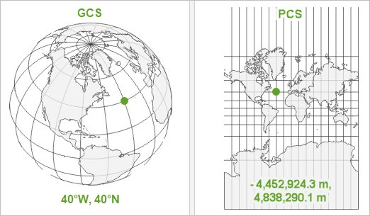
Geographic vs. Projected coordinate system
Defines where the data is located on the model of Earth’s surface.
A GCS is round, and so records locations in angular units (usually degrees).
Tells the data how to draw on a flat surface, like on a paper map or a computer screen.
A PCS is flat, so it records locations in linear units (usually meters).
Resources:
Note
Projection on the fly is what ArcGIS does to resolve conflicts when your data is in a different coordinate system than your map. It does this so the data can draw in the correct place on the map. Projection on the fly ensures that the data draws in the map’s coordinate system, even though it is still stored in other coordinate systems. ArcGIS will always apply projection on the fly when it’s needed. It can’t draw the data on your map otherwise.
Exercices:
Explore the impact of projection with interactive apps
Web Mercator distortion
The Web Mercator projection, an adapted version of the Mercator projection, has become the default map projection for web mapping. Unlike its predecessor, it employs a spherical formula consistently across all scales. Major online map providers, such as Google Maps, CARTO, Mapbox, OpenStreetMap, Esri, and others, widely employ this projection.
The primary advantage of the Mercator projection, and consequently the Web Mercator, is its preservation of direction, providing users with the valuable knowledge that north is consistently oriented upwards. Despite even distortion throughout most areas, as one moves away from the equator, distortion intensifies, causing significant stretching toward the poles. Consequently, the Web Mercator projection is unsuitable for polar displays. Due to these apparent distortions, it is not recommended for spatial analysis or area calculations.